 |
Like our website?
'Like' us on Facebook... |
|
|
Have you found this site useful? If so,
why not make a small contribution to our running costs. Just click
on the button below for more details:
|
Walking in the Lake District, UK - Helvellyn via Striding Edge |
A moderate walk in good weather, a challenge in poor conditions
Grade: |
Moderate |
Distance: |
19km |
Altitude Gained: |
~1100m |
Duration: |
6 hours |
England's Lake District, popularised by Alfred Wainwright and Tennyson alike, is probably the
most written about hiking area in the UK. And within the Lakes, Helvellyn, and in particular Striding Edge,
is probably the most notorious and well documented of them all.
So what makes Striding Edge so special? And why should we repeat here a route that has undoubtedly been described a multitude of times before? The answer is simple - it's a great route.
|

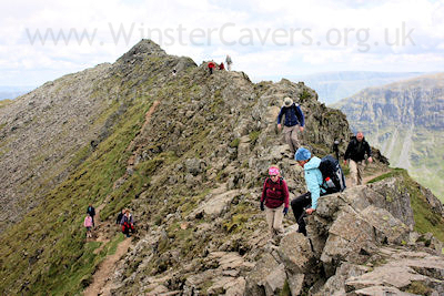
Above: The popular ridge of Striding Edge, May 2010
© Mat & Niki Adlam-Stiles, 2010
|
Walk in brief:
The ascent of Helvellyn via Striding Edge is an absolute classic of English hikes. The edge
itself presents no real difficulties in good weather, except for those in the minds in of
many an adventurer! In poor conditions Striding Edge would be an altogether different story, and
regardless of the weather, should be treated with respect by all who visit.
Those with a head for heights and a sure-footed gait will revel in Striding Edge's small, but
pleasant ridge. Those of a nervous disposition may be better off in the rather excellent
Daisy's Cafe in Ambleside!
|
|
|
|
Whilst there are several routes to the summit of Helvellyn, without doubt the most exciting and
most popular is via Striding Edge. An oft-quoted classic walk is "Helvellyn by the edges",
usually done by ascending via Striding Edge, and returning along the shorter Swirral Edge. Our route
ascends via the ever popular Striding Edge,
but from the summit of Helvellyn, we head south over the peaks of Dollywaggon Pike and Nethermost Pike to return
via the long descent along Grisedale Beck.
|
The ascent from Patterdale:
At the Southern end of Patterdale, a small car park, some public toilets and an
icecream shop help to get you set up for the day's walk. The obvious track
near (and opposite) the carpark entrance heads first west, and soon swings North
to skirt around the back of Patterdale and out towards the dales.
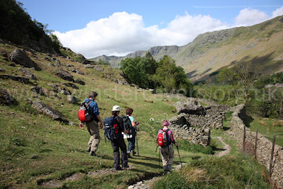
Easy walking brings you up-dale slightly, and to some old sheepfolds. From here drop down to the right to the small lane,
turn right down the lane for a short distance, before a left takes you over the bridge to the foot of Helvellyn proper.
Over the bridge, follow the path straight ahead and up the field, before turning left after the gate/stile.
Then keep right at a fork and you'll soon start to rise for the main pull up towards Striding Edge.
|

Right: The approach to Striding Edge, May 2010
© Mat & Niki Adlam-Stiles, 2010
|
Route-finding from here to the summit of Helvellyn is simple - head for the ridge, and keep on up! To stay on the very top
of the ridge that is Striding Edge is a real joy - those who find it a little too airy will be pleased to know that much of
the ridge can be traversed along paths just below the ridge, which are considerably less exposed. In good weather, the only
part that presents any real difficulty is the chimney climb (down) at the upper end of Striding Edge, and this is far easier
than it looks.
Having safely negotiated Striding Edge, the climb culminates in a rough scrabble, trending right (north) to reach the large
plateau summit of Helvellyn with its rock shelter and trig point.
|
Return via Grisedale Beck:
A popular return is to head North from the summit, and then Eastwards aong the shorter
Swirral Edge, to eventually meet up with
the lower part of the ascent route. Our route, however, heads South from Helvellyn's broad summit, to take in the
lesser peaks of Dollywaggon Pike, and Nethermost Pike.
A broad track, sadly characteristic of such a popular peak, heads Southwards towards Dollywaggon Pike. After a short while the main track
(and official footpath) heads to the right of the tops, avoiding a small amount of ascent, but thus missing the views down
Grisedale. As the main path veers right, a lesser track heads directly upwards, and we progress keeping close to the tops.
Only by doing so do you get to see a clear view of your ascent route, and of the descent route down the long Grisedale Beck.
|

Striding Edge as viewed from Dollywaggon Pike.
© Mat & Niki Adlam-Stiles, 2010
|
|
From the final summit, the main track down some large and knee-battering steps is easily gained, and one descends
first to the beautiful Grisedale Tarn, before heading East down the obvious route along Grisedale Beck. The long walk
out is uneventful, but pleasant throughout, eventually meeting up with the fork you encountered shortly after
crossing the foot bridge prior to your main ascent.
Back over the bridge, and left down the lane heads back towards Patterdale. As the road swings left, a footpath
on the right conveniently cuts off a corner, and delivers you neatly at the White Lion Inn for some well-earned refreshment.
|

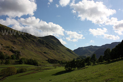
Grisedale Beck makes for a pleasant, but rather long walk out.
© Mat & Niki Adlam-Stiles, 2010
|
|
|
|
|