
 |
Like our website?
'Like' us on Facebook... |
|
|
Have you found this site useful? If so,
why not make a small contribution to our running costs. Just click
on the button below for more details:
|
Walking in the Peak District, Derbyshire,
UK - Bluebells in Clough Wood |
A short circular walk from Winster, Derbyshire through beautiful woodland.
Grade: |
Easy |
Distance: |
5km |
Altitude Gained: |
~150m |
Duration: |
1.5+ hours |
There are few thing more quintessentially English than strolling through a
wooded dale amongst a dense carpet of vibrant bluebells.
From the ancient lead-mining village of Winster, this short loop through Clough
Wood combines open farm land with mixed woodland, and some interesting features
from Derbyshire's lead-mining heritage.
|
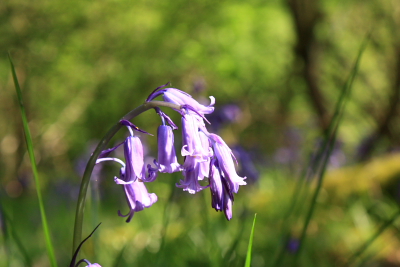
Above: Bluebells in Clough Wood, Winster, Derbyshire.
© Mat & Niki Adlam-Stiles, 2010
|
Walk in brief:
An easy circular walk mainly through woodland.
Some of the trails can be a little muddy in wet weather, but in the main clear
paths are followed and there are no navigational difficulties.
The walk starts at the public car park to the East of Winster at
SK245606. Winster has a small village shop and two pubs, giving ample choice
for refreshments before or after your walk. Parking is at a premium in the
village centre, so please do use the car park on the village outskirts. At the
time of writing, parking was free.
Refer to the Ordnance Survey Map OL24 (White Peak) for more ideas/information.
|
|
|
|
|
Starting from Winster:
From the car park at the Eastern end of the Village, we start by walking out along the
B5057 towards Wensley (East). Take care here as there is no footpath and visibility
for passing traffic is poor. This is the only section of road you will walk.
After about two hundred yards, go through the small wooden gate on the left,
taking the footpath that heads North East across the fields. You may notice that
the ground here is very "hillocked". These mounds are the remnants of old
lead mines - once a major industry in the area. Those with concrete railway
sleeper over the top are mainly mine shafts, some are as much as 300' deep.
|
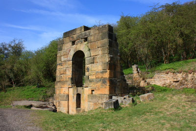
Above: Watt's Engine House - once housed a Cornish pumping engine used
to extract water from the adjacent Millclose lead mine - Derbyshire's White
Peak.
© Mat & Niki Adlam-Stiles, 2011
|
The route across the open fields is mostly clear, dropping downhill to bring you to
the edge of Clough Wood at SK252611.
From here, a clear path runs along the valley bottom, with a small stream to your right,
for approximately 1km. In early May, the woodland hosts a most impressive display of
bluebells - truly a magnificent sight - and as you progress along the valley bottom, you
may notice a few more tell-tale signs of Winster's lead-mining past.
After 1km you exit the woods, reaching some rough ground with the appearance of an
industrial wasteland - which indeed it is! These are the spoil heaps, or "tailings"
from part of the Millclose lead mine. In spring, the spoil heaps are host to an
abundance of the tiny white flowers of "leadwort" - an important metallophyte plant.
Follow the rough track uphill for a short distance until a second track coming in from the
left is seen at SK258618, and take this track, doubling back on yourself and heading due West.
If you reach an iron gate, you've gone too far.
|
Returning to Winster:
As you double back, you will soon come across the remains of "Watt's Engine House".
This fine structure once housed a steam pumping engine, used to dewater the mine below.
The adjacent iron grille covers "Watt's Engine shaft", some 200' deep, and to the rear
of the building remains you can see evidence of the flues.
Continue along the path to re-enter the woods, climbing gradually along a pleasant path
for just short of 1km. As you start to near the edge of the wood, you reach a junction
of two ways. Rather than follow the main path continuing straight ahead, turn left onto
the smaller path. This doubles-back slightly, before contouring round, and bringing you
to the woodland edge 1/2km later - SK252614.
|
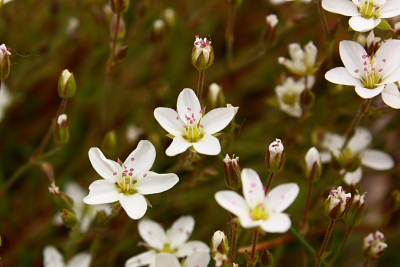
Above: The tiny white flowers of Spring Sandwort - known locally as
Leadwort.
© Mat & Niki Adlam-Stiles, 2010
|
|
|
Exiting the woods, head due West across the fields, passing the faint remains of the old
farmstead of Greatclose. Part way along the third field, descend along a line of sedge
to enter the woods and pick up a rough track dropping steeply to the valley bottom.
Cross the footbridge and climb up directly opposite, following the path which eventually
swings more Westwards and brings you back into the village. From here, a left turn along
the road soon brings you back to the car park.
|
|
|
|
|