Walking in the Lake District, UK - Low Hows Wood from Seatoller |
A short low-level walk in fine countryside - an ideal option when the cloud base is low.
| Grade: |
Easy |
| Distance: |
8km |
| Altitude Gained: |
~200m |
| Duration: |
3.0 hours |
When the cloud is down and all you'r going to see from "up-top" is grey fog,
there's still plenty to do in the Lake District.
This short, easy walk on good tracks starts from Seatoller, and has some
pleasant situations, and an interesting detour or two on-route.
|
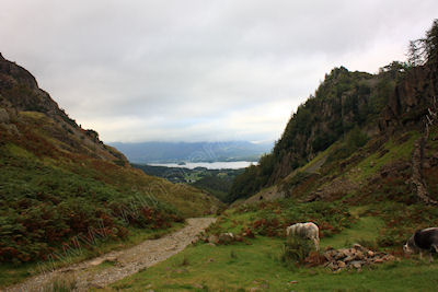
Above: Looking over to Derwent Water from Castle Crag - September 2012
© Mat & Niki Adlam-Stiles, 2012
|
Walk in brief:
The Lake District is undoubtedly one of the most beautiful areas in Britain. But let's face it, the lakes are there for a good reason - it rains a lot!
But when it is raining, or when the clouds down, there are still plenty of fine walks to be done without having to resort to furtling round outdoor shops and
visiting tea shops... not that there's anything wrong with that, of course!
This short walk is easy to navigate and on good footpaths throughout, and means you can feel you've earned your tea and tiffin.
|
|
|
|
|
The start from Seatoller :
From the small National trust car park at Seatoller turn right up the road towards Honister and through the village.
Just out of the village the road turns left sharply in from here footpath on the right lines moderately. Follow this
crossing over a track to reach a wall and gate and a T-junction. Turn right here (North) on a good track climbing gradually.
This pleasant path, part of the "Allerdale ramble", contours around the base of Dale Head, High Spy and Catbells on your left.
|
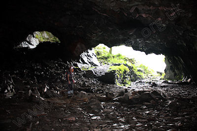
Above: Disused Slate quarries, May 2012
© Mat & Niki Adlam-Stiles, 2012
|
|
Crossing a couple of footbridges the small promontory of Castle crag and Low Hows Wood comes into view. As you approach Castle crag
you pass various footpaths on your right there to give you an option shortcutting the walk. Drawing level with Castle crag and optional
footpath on the right climbs steeply up to the disused slate quarry-an interesting detour if time allows.
From here, excellent views over Derwent Water are to be had.
Follow the track down through the woods keeping right to bring you down to the river Derwent. The Waterside here would make an excellent
spot for arrest and a picnic. Turn right following a pleasant path that climbs through the wood along the Waterside at first. An obvious
junction takes us left and back down to the Waterside. Another shortly detour can be made by turning right here and climbing up to another
part of the disused slate quarry.
Our main path now drops down to follow the river Derwent. Keep the river on your left at all times ignoring the tempting footbridges across
the river, eventually passing through the grounds of the youth hostel at Longthwaite.
From here the path continues passing behind the Glaramara our outdoor activity centre before dropping back down to the car park.
|
|
|
|
|