
 |
Like our website?
'Like' us on Facebook... |
|
|
Have you found this site useful? If so,
why not make a small contribution to our running costs. Just click
on the button below for more details:
|
Piton de la Fournaise - La Réunion's active volcano |
La Réunion's gem of an active volcano - Piton de la Fournaise
Rising up from the twisted-lava-filled caldera of the Enclos Foucqué like a child's drawing of what a volcano ought to look like, Piton de la Fournaise, La Réunion's "Furnace Peak", is a breathtaking sight.
Photo gallery - Piton de la Fournaise
From whichever direction you approach, you'll have had something of a long drive to get here. The volcano is sufficiently far removed from other inhabited areas that if you plan to visit, it's well worth your while to book a night or two at the appropriately-named "Gite du Volcan" close to the parking area and modest cafe/museum at the Pas de Bellecombe. All roads to the volcano converge at Bourg-Murat, where the 25km long Route Forestière du Volcan begins to snake its way across the surreal desert of the Plaine des Sables to la Fournaise. If you don't fancy the somewhat spartan and "cosy" dormitories at the Gite du Volcan, you could do worse than stay in Bourg-Murat – but you’ll need to make a very early start in the morning if you want to get to the top of the volcano before the crowds arrive and the cloud comes down for the day.
|
 
|
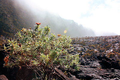
Early morning mist in the Enclos Foucque, Piton de la Fournaise, Ile de la Reunion, September 2009
(c) Mat & Niki Adlam-Stiles
|
Climbing from sea level to the volcano, you'll pass through an intriguing mix of terrain. You may start by travelling around the coast with little in sight other than field after field of sugar cane, then gradually rise into misty rainforest and canyons adorned with glistening white waterfalls. Here and there you'll pass through small, self-contained towns and villages (some more interesting than others ) with houses scattered across isolated green, level areas. Don't forget to stock up on food where you can – the closer you get to the volcano, the more difficult and expensive it will be to find something to eat! Once you are on the Route Forestière the scenery changes to a multi-coloured desert landscape, with a definite "volcanic" feel to it.
|
Although the final stretches of this road appear to be nothing more than a dirt track, the surface is good (and should be passable in all weathers). It's worth stopping off at the viewpoint for the jaw-dropping sight of the Rivière du Remparts gorge, which gouges a huge, ragged wedge out of the landscape all the way down to the sea at St. Joseph.
If you're going to the volcano, it would be a shame not to climb to the top - providing it's safe to do so. If it's not – for example, if an eruption is underway or imminent, there will be warning signs advising how closely you are allowed to approach. Take heed, and ignore these at your own risk. Even from the Pas de Bellecombe, the volcano is a magnificent sight and you shouldn't be too disappointed. At the time of writing (early December 2010) the most recent eruptions on Piton de la Fournaise have been in December 2009 (shortly after we returned – such is life!) and October 2010, and it appears that there are rumblings afoot once more.
The website www.fournaise.info is an excellent source (in French) of up-to-date information on what's happening at the volcano. Additionally, the
La Reunion pages of the Office National des Forêts web site provide constantly-updated information as to which paths on the island are currently open, with downloadable pdf maps (again, of course, in French).
The ascent of the volcano, although seemingly straightforward, is not (as is indeed the case with any active volcano) to be undertaken lightly. Early in the morning (the best time to start your climb and the most likely chance of getting a cloud-free view from the summit) it can be very cold up here (the volcano is a respectable 2362m high). Take a warm layer and light waterproofs, as the mist up here can leave you soaked through, and if rains, you’ll end up in a miserable state. Make sure you also have some food and plenty to drink; you’ll get more dehydrated than you realise, and ensure you have decent walking boots as the terrain is pretty rough underfoot.
|
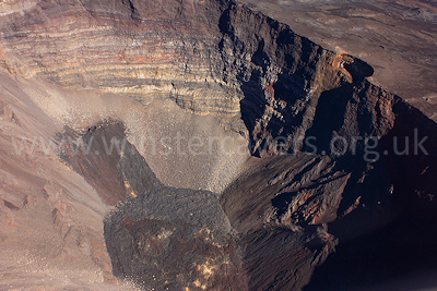
An aerial view of the Dolomieu crater - the dark lava flows are from the small eruption of January 2009
(c) Mat & Niki Adlam-Stiles
|
If you are staying at the Gite du Volcan, it'll take you about quarter of an hour to reach the Pas de Bellecombe and the start of the volcano path or "Sentier due Volcan". From the Pas de Bellecombe, follow the clearly-signposted path down a seemingly endless flight of steps (in reality, there are 527) to emerge in the Enclos Foucqué's twisted lava field. The path from here is perfectly clear; white paint splotches head directly towards the central cone of the volcano. Follow these, passing in a short while the red, cindery cone of Formica Leo and shortly before the ascent to the top, a large lava cave known as the Chapelle de Rosemont. If the path to the top is closed this may be the furthest you can walk – it's still an impressive spot, though sadly the Chapelle itself has become something of a toilet for inconsiderate visitors.
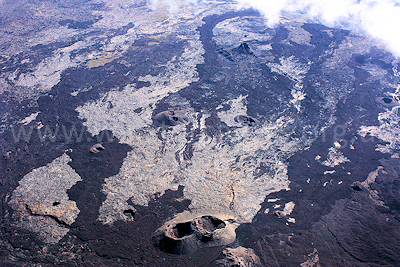
An unusual aerial view of the lava flows in the caldera of the Enclos Foucque, Piton de la Fournaise, Ile de la Reunion, September 2009
(c) Mat & Niki Adlam-Stiles
|
It's a good place to stop and ensure you've got a decent amount of sunscreen on, and to have a drink, before tackling the next part of the climb. There are two ways up from here; the right-hand route will take you directly, via a steep 300m ascent, to the Bory Crater. Most people can't resist going up this way! The left hand route is more gradual climb up, passing through some superb variations in colour of the different lavas, to the Dolomieu crater. Take care on either path; loose, cindery rocks abound here and cuts sustained on the lava can be particularly nasty. We always carry a first aid kit, even on a walk like this where you're bound to encounter other people. Cuts and grazes can get messy and are easily infected – best to be able do something about them immediately.
|
The route we took was the right-hand one, and if you're early enough, you'll enjoy spectacular views into the Bory crater in the one direction and Piton des Neiges, La Réunion's highest peak, across the caldera in the other. Keep heading right once you reach the crater, and you'll soon reach the Dolomieu crater, an immense pit where you may see – and hear – bits of the crater falling in on itself. Heed this as a warning and be careful not to go too near the edges. Shockingly, you will often find that having walked a few metres further along the path, that handy little viewpoint you were standing on five minutes ago turned out to be a crumbling overhang. When we did this walk, we walked for maybe half an hour along the edge of the Dolomieu crater (anticlockwise) but felt that the terrain was too dangerous at the time to continue (there were warnings of an imminent eruption, and one did indeed occur some weeks later). We saw a lot of others turn back too.
In theory, when it's declared safe to do so, you can walk all around the two craters. We returned and walked clockwise for some distance around the craters, which gives an completely different impression of them – and if anything, an even better idea of their massive size. By now the cloud may well have come down and enveloped you, so it’s a good idea to start heading downhill. We returned along the more gradual climb, which afforded some superb views when the cloud temporarily lifted. Follow the track back to La Chapelle de Rosemont and thus back to the Pas de Bellecombe. If you’re doing nothing other than a determined walk you can do the whole thing – including the tour around the top craters – in about five hours. Allow plenty more if you want to take pictures and stop to admire the scenery!
|
|