
 |
Like our website?
'Like' us on Facebook... |
|
|
Have you found this site useful? If so,
why not make a small contribution to our running costs. Just click
on the button below for more details:
|
Walking in the Peak District, Derbyshire, UK - The traverse of Lathkill Dale |
A long circular walk on clear paths - full of interest.
Grade: |
Moderate |
Distance: |
18km |
Altitude Gained: |
150m |
Duration: |
5+ hours |
Lathkill Dale is one of those places that you can never really get bored with.
Simply beautiful scenery is complemented with superb opportunities to see
wildlife, Natural Caves, Mines and some excellent industrial archaeology.
The suggested walk takes on a whole new character if done in reverse - do it
twice!
|
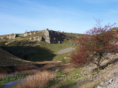
Above: Lathkill Dale, Derbyshire.
© Mat & Niki Adlam-Stiles, 2010
|
Walk in brief:
The full traverse of Lathkill Dale and the Bradford Dams is a lengthy
undertaking, but makes for an excellent day out full of interest.
Despite the
length of the walk, there is little in the way of steep ascents. Good
paths are followed for almost the entirety of the walk, and there is little
navigational difficulty.
The walk starts from the popular Derbyshire village of Monyash, which offers a
good pub and an excellent hiker-friendly cafe. Public toilets can also be
found at the Eastern end of the village, from where our walk starts.
The walk is covered by the 1:25,000 Ordnance Survey map OL24 (White Peak)
|
|
|
|
|
The start from Monyash:
Parking can usually
be found in the centre of Monyash Village, or better, there is parking for a few
cars just outside the village by the public toilets at SK157665.
To the left of the toilet car park a gate gives access to the main public foot
path down to Lathkill Dale - the start of our walk, and just a few meters away
from one of the first points of interest. By going through the gate and
climbing the embankment behind the toilet block you can find the entrance to
Cascade Cavern" - a rectangular metal "manhole cover". Entrance to this
cave, however, is the reserve of suitably equipped and experienced cavers, as
the entrance immediately drops some 20+m
|
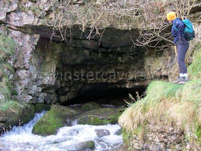
Above: The resurging entrance to Lathkill Head cave
© Mat & Niki Adlam-Stiles, 2010
|
Follow the main footpath across the field and slightly down-dip. After two
field boundaries, keep straight ahead and downwards, to start descending into the
dale proper. You soon enter the dale head, with evidence of ancient quarrying all
around - wonderfully naturalised. Follow the path down as it winds amongst
the boulders and vegetation. On the left as you descend is the
long-abandoned Ricklow quarry - you can see evidence of the old tramming ways
high above -
and also Ricklow cave, a long natural tube.
After ~1.5km the dale starts to open out, and as it does so, Lathkill Head Cave
lower entrance comes into view. This large natural arch is often dry
in Summer - but in Winter a strong river issues from its flooded depths.
The magnificent views down Lathkill Dale continue to open up as you descend,
bringing you to a footbridge after another 0.5km (SK174665). We save
Lathkill Dale itself for our return journey, and head across the footbridge and
up the smaller, verdant Cales Dale, passing the numerous small Cales Dale caves
as we do so.
The Cales Dale path starts to climb steeply, heading into the open at One Ash
Grange. As it does so, a path on the right drops down to the valley bottom.
Follow this (the Limestone Way) down, cross the stream, and then climb the short
but rather steep dale side before breaking out into open pastureland. 2km of
easy walking through farmland brings you, via
Calling Low farm to a road.
|
Descending to Bradford Dale:
The Limestone Way emerges at a fork on the road. Ensuring you have the
right fork (Moor Lane) continue along the Limestone Way - a few yards of walking
along the lane, followed by the path heading off right by the small car park.
In the copse behind you is Longrake Spar mine - off limits to the public.
The limestone way drops down past some disused mine shafts (look for the Mere
Stone in the field that denoted the boundary between lead mine titles) before
intersecting the Youlgreave road. Turn left along the road for a few yards,
before the path continues on the right, dropping through the Lomberdale Hall
estate grounds to reach the Middleton Road.
|
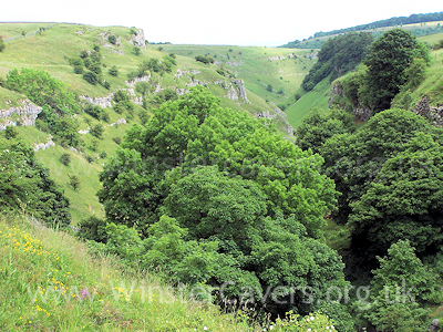
Above: Looking down onto the hidden delights of Lathkill Dale.
© Mat & Niki Adlam-Stiles, 2010
|
|
Turn right along the road. After about 0.25km, the Limestone way continues
on the left, dropping steeply through the woodland (care - this can be
slippery) before eventually emerging at a small bridge close to the head of
Bradford Dale.
Bradford Dale to Alport:
Follow the river bradford downstream through the beautiful Bradford Dale.
If you look carefully, you'll probably see Little Grebes (known as Dab Chicks
locally), dippers - and if you're really lucky, you may even see Peregrin
Falcons high above the dale. On the right hand side towards the lower
section of the dale, another mine entrance can be seen.
1km of super, easy walking brings you to a foot bridge. Cross the bridge,
and continue downstream on the opposite side of the river in the rather more
open dale. When you reach the lane, go straight across and continue to
follow the river, bringing you after ~3/4km to the tiny hamlet of Alport.
When you reach the road, cross over, and take the foot path that runs alongside
the river, heading upstream. This is the very lower end of Lathkill Dale.
|
|
Returning via Lathkill Dale
Heading upstream for just over 1km takes you first past a very minor lane, and
then to the Conksbury road. Head right along the road as it drops briefly
but steeply to the old Conksbury bridge. Cross the bridge, and then follow
the footpath that runs along the riverside (or if you're in need of refreshment,
the path that climbs up from the hairpin bend slightly higher up the road will
bring you neatly to the Lathkill Hotel in Over Haddon!)
From here, route finding is easy. Clear paths take you along the banks of the
River Lathkill for some 4km, where you reach the foot bridge you crossed on the
outward journey, and return by repeating the last 2km but in reverse.
|
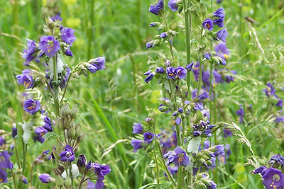
Above: Jacobs Ladder, just one of the many fine wildflowers to be found in
Lathkill Dale
© Mat & Niki Adlam-Stiles, 2010
|
|
As you ascend Lathkill Dale, there is plenty of interest. As well as the wildlife
mentioned on the Bradford Dale section, look out for the various abandoned lead
mines - first a small trial level on the right, then the outflow of Mandale
Sough (mine drainage level) on the left. Shortly after Mandale Sough, a
brief detour on a path heading up on the right brings you to Mandale Mine
(access for bonefide cavers only) and the remains of the impressive waterwheel /
pumping engine house.
A little further upstream are some stone pillars. These are the remnants of
an aqueduct that once supplied water to the Mandale engine.
Continuing further upstream, a wooden footbridge crosses the river and takes you
to Batemans house - an old mine agents cottage. Descend the metal
staircase to find it's hidden secrets - winding the big metal handle will
illuminate all!
And as you approach the more open ground, look out for the wild flowers.
Orchids can be a common site, and the Jabobs Ladder further up the dale can put
on a splendid display of deep purple flowers.
|
|
|
|
|