
 |
Like our website?
'Like' us on Facebook... |
|
|
Have you found this site useful? If so,
why not make a small contribution to our running costs. Just click
on the button below for more details:
|
Walking on Etna - Ascent routes to the summit craters from Etna Sud |
Hiking trails (ascent routes) from the South side of Mount Etna to the summit zone
(2900m).
Grade: |
various |
Distance: |
various |
Altitude Gained: |
up to 1000m |
Duration: |
various |
Getting to the top:
Starting from the Sapienza car park, you can make the ascent as hard, or as easy as you wish, depending on the level of
mechanical assistance (i.e. the cable car & jeep) you wish to take advantage of! For the agile, descending Etna is swift
and easy, but the ascents can be hard work.
We refer here to the "summit zone" – a sort of plateau situated at ~2900m altitude, above which rise the actual summit
craters of Mount Etna, which top-out at just over 3300m high.
Described here are some of the options for getting to the summit zone.
|
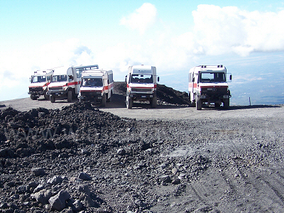
Above: The easy way to get to the summit zone of Mount Etna - jeeps parked at the upper cable car station, Piccolo Rifugio, September 2007
© Mat & Niki Adlam-Stiles, 2007 |
|
|
Grade: |
Very Easy |
Distance: |
2km (cable car) |
Altitude Gained: |
600m (cable car) |
Duration: |
various |
|
Taking the cable car on Etna Sud can save you about 500m of ascent and, in my humble opinion, the ~€13 for a one way
ticket is well worth it. Ask for a ticket "Solo Andate" for a one way trip. This will get you as far as Piccolo Rifugio
at ~2500m, the point from where the Jeeps depart for the now-defunct Torre del Filosofo and the top craters. If you
really want, you can get a "one way" ticket to include the jeep, but you have to pay for the full "short tour" and then
abandon the group at the top! Expect to wave good bye to ~€35+ for a one-way ticket to the Torre del Filosofo.
|
|
|
|
|
Under your own steam – The jeep track: |
Grade: |
Strenuous |
Distance: |
3km |
Altitude Gained: |
1000m |
Duration: |
~3 hours |
|
Those wishing to shed a few calories (and believe me, you will!) can make the full ascent from Sapienza on foot –
gaining a total of some 1000m of altitude. For the navigationally challenged, head for the base of the cable car
station.
To the right of it the rather obvious jeep track starts to rise up, and this can be followed along numerous
switchbacks to Piccolo Rifugio, and then further upwards to the Torre del Filosofo / Rifugio Alpino. It's not
actually the most exciting way to the top, but apart from the altitude gained, it's relatively easy going under
foot on clear solid tracks.
|
|
Under your own steam, via La Montagnola: |
Grade: |
Very Strenuous |
Distance: |
3km |
Altitude Gained: |
1000m |
Duration: |
~4 hours |
|
If you want to make it especially hard for yourself, follow the "descent via La Montagnola" in reverse.
Climbing the ashy slopes is, however, extremely strenuous. You have been warned!
|
|
Under your own steam, via the Schiena Del Asino: |
Grade: |
Very Strenuous |
Distance: |
5km |
Altitude Gained: |
1100m |
Duration: |
~4 hours |
|
If you're going to do the full ascent from Sapienza by foot, then the ascent via the Schiena dell Asino certainly has
something to offer. When things are feisty up-top, it’s a favourite with the locals for gaining a superb vantage point
in relative safety.
It’s a short walk from Sapienza down to the starting point of the ascent of Etna via the Schiena del Asino route.
Follow the "extended route" up the ridge to the base of La Montagnola, and when you pick up the faint track in the ash cones,
turn right to skirt around the East side of the impressive crater. From here you're on the "Descent via Montagnola", but in reverse,
and can logically pick up the route along the top (Western) edge of the Valle Del Bove to Belvedere.
Hard work, but recommended.
|
|
From Piccolo Rifugio to the Torre del Filosofo / Rifugio Alpino via the jeep track: |
Grade: |
Moderate |
Distance: |
2km |
Altitude Gained: |
400m |
Duration: |
1 hour |
|
The Jeeps all stop at a small wooded hut & turning/parking area by the now lava-encased Torre Del Filosofo. Assuming you’ve
made it as far as the cable car upper base station at Rifugio Piccolo, you have three good options for the ascent. The
easiest underfoot, and the easiest to navigate, is to stick with the jeep track. As you exit the cable car station, some
steps on the right allow access to the jeep track without getting caught up in the new (2008) turnstiles and the associated
touristic throng. This otherwise uninspiring track, on which getting mown-down by a high-speed Unimog is a real possibility,
has as its main redeeming feature, ever improving views on the top craters - in particular, as "Sud Est" comes into view
steaming away – or more. It also provides a relatively easy-going ascent of the next 400m of altitude.
A short distance before Rifugio Alpino there is an obvious left-hand bend in the Jeep track. Note this point, as it makes for
a convenient route toward the eastern side of the craters, and one of the best close-up views of Sud Est.
|
|
From Piccolo Rifugio to the Torre del Filosofo - via Monte Escriva & the Belvedere: |
Grade: |
Moderate |
Distance: |
2km+ |
Altitude Gained: |
400m+ |
Duration: |
1.5+ hours |
|
Proceed along the jeep track to where the new ski-run / cable car comes in on the right, between La Montagnoloa & the adjacent
Monte Escriva crater to its North. Either strike off at right angles to the jeep track, and up the pass between the craters
along the ski run, or better, walk along the west side of Monet Escriva (the North Crater), and double back on the rough track
that climbs (very) steeply to its top. The climb to the top is strenuous and the going is awkward underfoot, but the crater
is very impressive, and it's worth the effort. If you've made it to the top of the crater, skirt around to the far (Eastern)
side with care – a fall here would be pretty unfortunate - and carefully pick your way down the extremely awkward crater slopes
towards the North East. For those who have scrambled along by the new ski lift, trend north (left) around the crater.
Either way, you'll find yourself working towards the upper edge of the impressive Valle del Bove. Head North along the edge,
where a rather intermittent stick-and-rope arrangement defines the safe limits for hikers. Make your own judgement of how close
to the edge you wish to get – the views are superb, but some of the ground is not to be trusted.
As you proceed Northwards, you'll pass the significant crater, Cisternazza. It's easy to end up on the western side of the
Cisternazza crater – the views are better if you keep to East. Peer down into the void, but be warned – those who clamber down
its steep, loose sides will seriously struggle to get out! Carrying on hiking Northwards, the "Belvedere" is probably the best
vantage point over the whole of the Valle Del Bove, marked by a small shrine.
Work your way along the rope-line until the INGV monitoring station comes into view – easily identified by the large solar panels and
other gadgets. It you’re heading towards Rifugio Alpino and the very tops at the Bocca Nuova, you'll want to strike off to the left
(West) and rejoin the jeep track before you get to the Monitoring station. Alternatively, there is usually just sufficient shelter
adjacent to the station to make a fine spot for lunch, and to observe and contemplate the steamy SE crater!
|
|
From Piccolo Rifugio to the Torre del Filosofo - via Monte Frumento Supino (almost): |
Grade: |
Moderate-Hard |
Distance: |
2km |
Altitude Gained: |
500m |
Duration: |
1.5 hours |
|
From Piccolo Rifugio, start walking up the jeep track, as per the other two ascent routes. A short way past the new
ski lift the ground opens out – to the right are open views towards the coast and the Valle del Bove, and to the left,
the twin craters of the 2001 eruption / Monte Frumento Supino - usually identifiable by the line of tourists being
led around the rim of the Northernmost of the craters. A direct-line can be made towards Monte Frumento Supino –
you'll note an ashy track heading upwards and right to a point between the two craters. To the base of this track
is relatively easy going, although the ground underfoot resembles walking on a sand dune. The pull up the track to
the crater rim is a short, yet rather strenuous ascent - those who have taken walking poles with them will be grateful
for the extra traction!
The views are, however, well worth it - and if you're traversing round to the Bocca Nuova it makes for a rewarding
round-trip. With Sapienza far below you, skirt around the northernmost of the craters whichever way suits, to arrive
at the jeep park by Rifugio Alpino.
|
The google map (below) has each of the main routes marked on it, with key way-points also. Zoom in on the map for more detail,
and/or click on any of the routes/way points for further information.
View Larger Map
|
|