
 |
Like our website?
'Like' us on Facebook... |
|
|
Have you found this site useful? If so,
why not make a small contribution to our running costs. Just click
on the button below for more details:
|
Walking on Etna - Descending from the summit craters on Mount Etna, Sicily |
Hiking trails (descent routes) from the South side of Mount Etna to Rifugio Sapienza.
Grade: |
various |
Distance: |
various |
Altitude Gained: |
n/a |
Duration: |
various |
Getting back down:
Having explored the summit of Mount Etna, at some point you'll need to tear yourself away and get back down!
Short of taking the jeep / cable car back down, there are three logical descent routes back to Sapienza.
A fourth route could be made by reversing the ascent of the Schiena dell Asino, which has in its favour a
superb outlook towards the Catania coast line, but is otherwise best treated as an ascent route.
The best route for you will depend on how exhausted you are, your familiarity with the terrain and, importantly,
weather and daylight conditions. If Etna is in eruption, you will probably want to stay up-top until dusk,
or beyond, in which case you may be best choosing one of the safe descent routes, such as the jeep track.
Please note: that distances and times are very approximate, as it will depend on where you are
starting from!
|
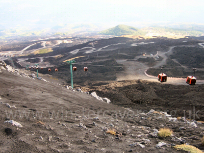
Above: One of the easy ways to descend Mount Etna - alongside the cable car run, September 2007
© Mat & Niki Adlam-Stiles, 2007 |
|
Trekking on Etna - Descending via the Jeep Track. |
Grade: |
Easy |
Distance: |
2km + |
Altitude Gained: |
n/a |
Duration: |
2-3 hours |
|
The Jeep track makes for a safe, if rather long-winded descent. Personally, I find it a little tedious and hard
going on the knees, but if the weather is against you and visibility is poor, or if you're unfamiliar with the
terrain and are descending in darkness, it's a pretty fail-safe way to get off the mountain. It's even been
heard of for benevolent jeep drivers to offer free lifts to soggy hikers on their way back down
(thanks guys, it was appreciated!).
|
|
|
|
|
Hiking on Etna - The descent via La Montagnola: |
Grade: |
Moderate |
Distance: |
3km |
Altitude Gained: |
n/a |
Duration: |
1.5 hours |
|
The finest route down the South Side of Mount Etna is undoubtedly the descent via La Montagnola. Those unfamiliar with the route
will be largely reliant on the far reaching views you get down to Sapienza (so you know where to aim for!) and are probably best
avoiding this route in poor visibility. La Montagnola is the large crater close (East) to the cable car station, identifiable by
the volcano monitoring station on its summit. The descent route described assumes that you have made it at least as far as the ski
lift to the North of La Montagnola, and probably as far as Rifugio Alpino or Belvedere.
|
|
If you're heading back down from Belvedere, keep close to the rope & stick "fence" that marks the safe limits for trekking, and head
South towards the impressive craters, passing the pit crater of Cisternazza on your right.
If you're hiking back from Rifugio Alpino either by descending from Frumento Supino, or by following the jeep track, look for the
well travelled and broad route that skirts around the North side of the northern-most crater from La Montagnola to the East side of
the jeep track, heading direct for the head of the Valle del Bove.
As you skirt around La Montagnola, the track becomes a more distinct, thinner line contouring around the crater in the ashy slopes.
Far below on your left is a fairly serious drop down to the Valle, and a descent route into the Valle for those who know it. The
ground is more solid that first meets the eye, but it has been known to test the nerves of those prone to vertigo.
Follow the path at a contour right round to the South side of La Montagnola, passing an unclear ridge on the left that is the ascent
route from the Schiena, until the Silvestri Craters and Sapienza come into view.
Once the Silvestri Craters are directly below you, you can take a short-cut by descending directly down the loose, ashy slopes. Pretend you're
skiing, and you'll rattle down a phenomenal distance in a matter of minutes. You'll note a "rib" of vegetation pointing upslope.
Head just to the right of this, and then swing right as you approach more level ground.
From here a network of paths skirts the various craters, but eventually all of them will take you back to Sapienza. A highly
recommended route, best done in daylight.
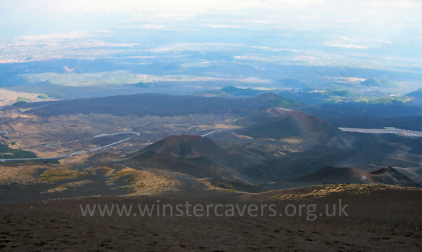
Above: One of the finest ways to descend Mount Etna - direct from La Montagnola, September 2007
© Mat & Niki Adlam-Stiles, 2007
|
|
Walking on Etna - Descending by (not in) the cable car. |
Grade: |
moderate |
Distance: |
2km |
Altitude Gained: |
n/a |
Duration: |
~45 minutes |
|
Having made your way back as far as Picolo Rifugio a surprisingly jolly, and fast, way to descend is to hike down the very steep ashy slopes
directly beneath the cable car.
Watch out for hidden lengths of the old cable / base stations as you descend rapidly and directly towards Sapienza. As you
approach the ski run, you can go straight ahead and walk down the piste, but better is to veer left and stay on the ashy
slopes until you draw almost level with Sapienza. Hard lava flows will push your route left and away from the cable car slightly.
As you draw level with lower base station of the ski lift, you can climb over the lava flows to pick up the jeep track just a
few yards from Sapienza – although you may well have gone slightly off-course and ended up on the lower section of the jeep track
before that point anyway. It's easily done, and doesn't really matter.
|
The google map (below) has each of the main routes marked on it, with key way-points also. Zoom in on the map for more detail,
and/or click on any of the routes/way points for further information.
View Larger Map
|
|