
 |
Like our website?
'Like' us on Facebook... |
|
|
Have you found this site useful? If so,
why not make a small contribution to our running costs. Just click
on the button below for more details:
|
Walking in the Lake District, UK - Haystacks via Fleetwith Pike |
A fine walk, mixing the popular Haystacks with the more rugged Fleetwith Pike
Grade: |
Moderate (hard) |
Distance: |
15km (19km) |
Altitude Gained: |
650m (1050m) |
Duration: |
5 hours (7 hours) |
Second only to the Lake District's Helvellyn in popularity comes Haystacks - a rugged
little promontary easily scaled, and popularised by Aflred Wainwright having had his
ashes scattered on its rocky tops.
With a more than ample scattering of tourists populating the summit
of Haystacks, one could easily postpone this excellent walk for another day - but
the acsent via Fleetwith Pike seems to deter the masses, and makes for a most excellent
day out in the hills.
|
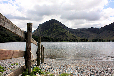
Above: Looking along Buttermere to Fleetwith Edge and Haystacks - May 2010
© Mat & Niki Adlam-Stiles, 2010
|
Walk in brief:
The ascent of Haystacks is most popularly excecuted by starting at Gatesgarth Farm
(NY194150). From here, an easy route up Warnscale bottom takes one "relatively"
effortlessly to tops of Haystacks and the beautiful
Inominate Tarn, Alfread Wainwrights final resting place. A brief scramble over
the tops, and one can descend Haystacks via Buttermere Fell and return to Gatesgarth Farm in just a few hours.
Whilst the above is undoutedy a fine walk, this extended walk takes in not only
Haystacks,
but the larger part of the beautiful Buttermere lake, and the exciting ascent of Fleetwith
Pike - an undertaking far less intimidating than one might think and
well worth the small amount of extra effort.
|
|
|
|
|
The start from Buttermere:
Our walk starts at the small village of Buttermere itself, where the early birds
may find some on-road parking - others will have to make use of the small National Trust car park at the Northern end of the village.
Start out on the footpath through Wilkinsyke Farm (convenient toilet &
icecream stop!) to pick up the permissive route along the Nothern side of Buttermere.
From here 2km of easy walking by the wonderful lakeside will bring you, via a short
on-road section, to Gatesgarth farm. At various points it is possble to descend
a few feet to the waterside, where the early morning light can offer superb photographic
opportunities.
|
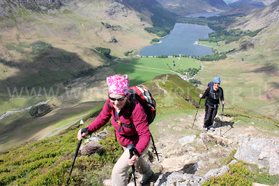
Above: Enjoyable walking on the excellent ascent of Fleetwith
Edge, May 2010
© Mat & Niki Adlam-Stiles, 2010
|
|
At Gatesgarth Farm three paths heads right. The first is to Peggy's bridge,
the common return route for the popular Haystacks circular walk. The second brings you to Warnscale
Bottom, a commendable ascent route. Just a few yard further up the Honister
road, a third path heads right. This is our ascent route which, without futher
to-do makes a direct ascent of Fleetwith Edge. The ridge is far less intimidating
than it looks at first, rising in a series of steps, each more lofty than its predecessor.
As you climb, take the time to look back - the views over Buttermere and Crummock
water are perfect in every way. After 1km of relentless but rewarding climbing,
you'll reach the summit cairn of Fleetwith Pike.
|
From Fleetwith Pike to Haystacks:
From the summit of Fleetwith Pike (NY205142) the official footpath heads initially
due East before turning South East towards Bell crags (NY218137), from which the
main Honister Hause - Haystacks path can be picked up. If you're up for a
little "off-piste" a series of sheep tracks, augmented by human footprints, will
take you direct to the abandoned slate workings of Dubs Quarry, joining the Haystacks
path at ~NY210136. From here, follow the track west for a short while before picking
up the obvious foot path to Haystacks.
|
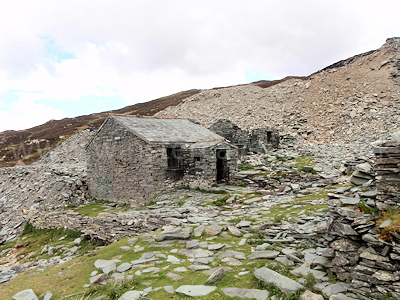
Dubs Hut - at the disused Dubs Quarry.
© Mat & Niki Adlam-Stiles, 2010
|
|
Passing the Warnscale bottom ascent route on your right, the clear path climbs to
just-short of the summit of Haystacks, and the two summit tarns - first
Blackbeck Tarn, then the smaller Inonimate Tarn. The path skirts around
the western edge of the summit - a brief detour to the very summit
(there is actually a series of craggy minor summits) will afford you the best views.
Depending on your chosen route, descending from the final summit may require a small amount of easy scrambling.
The path here has diverged, and it is easy to inadvertently head too far "in-land",
only to find yourself back-tracking slightly to reach Scarth Gap (NY189 133) - the saddle between Haystacks
and High crag / High Stile. From here, you have two options for the return to Buttermere.
Return via Buttermere lakeside
At Scarth Gap the main track heads due North, dropping down in large steps to Peggy's Bridge and the Buttermere waterside. From here, do not cross the foot bridge, but instead keep left
following the path along the side of Buttermere. A little short of 1km of level, open path will bring you to a fork, where you have the choice of following the permissive route (right) and keeping
to the waterside, or forking left and climbing very slightly through Burtness wood. The routes converge at the far Western edge of Buttermere.
From end of Buttermere, a bridleway heads North accross a foot bridge, returning to Buttermere village after ~ 1km
|
|
Return via High Crag & High Stile (+400m ascent)
If you're up for a more energetic return, from Scarth Gap you can climb up the path to the North West to gain the lesser summit of "Seat", and then via a small saddle climb
again to reach the summits of High Crag, followed by High Stile (806m, NY167147). From here a route drops steeply down to Buttermere, but better is to stay high and traverse
the broad ridge to Red Pike. A short distance past the summit of Red Pike a junction is reached. Right drops steeply via Bleaberry Tarn to the Westerm tip of Buttermere.
From end of Buttermere, a bridleway heads North accross a foot bridge, returning to Buttermere village after ~ 1km
|
|
|
|
|