Trekking in the High Atlas, Morocco. The Blog 2013
After a little procrastination of the "when shall we go back to Etna" style, a couple of wild-card alternative ideas, and a few e-mails, we find ourselves with flights booked to go to Morocco for a 10-day trek through the High Atlas mountains. Our itinerary lists lots of places we can't find on the map, so for 10 days we'll don walking boots, and put our trust in our guides and our mules - it should make for a pleasant adventure!
(We expect Internet access to be very intermittent/non-existent in the mountains - our musings will get uploaded as & when we get a chance!)
4th September 2013 - Manchester to Marrakech
The e-mail from Mohamed the night before departure with an amendement to our itinerary was somewhat reassuring - it meant that he'd grasped the fact that our flight wasn't going too get in to Marrakech until 20:00 hrs.
We arrived in Marrakech bob-on time, and were delivered with pleasant efficiency to the perfectly comfortable Riad Taghazoute, just a couple of minutes walk from Marrakech's busy main square. We ate well, before strolling though the square with its plethora of market stalls, oozing vibrant colours and smells both good and not-so-good. What an amazing place!
Thursday 5th September 2013 - Imlil to Oukaimeden (aka "desk jobs are bad for you")
We left Marrakech at 9:00am prompt, and were driven to the vibrant little mountain town of Imlil in the foot of the Atlas mountains. Here we met Mohamed, our tour organiser, and Ibrahim, Ibrahim and Hassan. A short drive later and we met our Mules, before starting out on our trek to Oukaimeden, via the village of Tachedirt and over the Tizi n'ou Addi pass. The unspoilt landscape is stunning - small villages blending into the mountainside, clear blue skies and seemingly endless skylines. The total of 900m of ascent, 400m of descent and 15km seemed somewhat harder than it should - spending one's weekdays working at a desk clearly isn't good for you!
We camped in a wonderful open valley, and watched the surrounding mountains as the setting sun cast its golden rays upon them whilst shepherds and goatherds brought in their respective flocks and herds for the night. As the sun dropped, so did the temperature. Somehow this is unlikely to stop the Winster Cavers sleeping well tonight.
Friday 6th September 2013 - Oukaimeden to Timichi
After a surprisingly restless nights sleep we rose early and by 8:00am we were on our way again - only half an hour later than planned. We walked down towards the centre of the ski resort of Oukaimeden, before heading out along the vast Tiferguine valley, past the small hamlet of Azib Tiferguine, and upwards to the col at Tizi Ouhattar (3130m). The view from the col was truly spectacular - to the West, Oukaimeden was clearly visible far, far below, and to the East, new views down the villages of Agounss and Tinoummer.
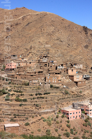
We descended rapidly, down the stony zig-zag path, to lunch by the riverside at Agounss. Here, stone houses nestled amongst neatly tended terraces of maize, potatoes, and other crops - a green oasis within the harsh granite landscape.
As lunch ended, the clear blue skies gave way to some rather dark clouds, and so the rain started - a brief but pronounced downpour. Thankfully, it was a short walk from here to our resting place at Gite d'Etape Brahim Oussalem at the small village of Timichi (1975m). After today's 16km hike, the tepid shower was pure luxury. Tomorrow's jaunt is destined to be shorter and easier - a chance to recharge before we head out into the wilderness.
Saturday 7th September - Timichi to Setti Fatma
When is an 8km walk not an 8km walk? When it's a 13km walk, that's when!
Yesterday's rain started up again during the evening, and continued throughout the night. We awoke to grey skies, and the not-so-nice prospect of a day or several of hiking in foul weather. We'd not walked for more than a km or two before the waterproofs went back on again. Our route took us along the impressive Assif Ourika river valley, mostly on the new gravel road high above the river that had been built on top of the old mule track. You can see why the road, and the shiny new pylons delivering electricity to these small mountain villages are wanted, indeed required - but it does detract slightly from the remoteness of it all. And the white satellite dishes perched on the roofs of each and every house look more than a little incongruous.
We passed through the remote villages of Timguist, Isgouarne, Tiourdou, Anfli and Tadrart. As the rain continued, we took shelter in an archway in one of the villages - pretty affairs with stone built houses stacked up against the valley side. As we sheltered, the possibility of a change of plan was discussed. Ibrahim explained that the next three days would be in open, wild country, and if the weather was bad there would be little scope for finding shelter. Moreover, there were several river crossings to be done, which could be hazardous if the rivers were high. We agreed to, quite literally, take a rain check when we got to Setti Fatma and if necessary to change our route.
As we continued along the road the views over the valley opened up, revealing an ever widening vista. Beyond the valley sides distant ridges and mountain tops became visible, topped with the first scattering of snow from last night's downpours. We continued along the valley, the rain thankfully stopped, and the skies showed vague signs of clearing. Our short walk turned out to be ~14km - relatively easy going, but the two days previous hiking had made for weary legs. We arrived at Setti Fatma for lunch, and set camp on a scrap of land by the edge of the village. As we write the sky is clearing, so hopefully tomorrow we will head into the wild. If we do, we can expect a few tough days in the mountains - we've descended now to 1500m, at 4167m high, the summit of Toubkal, our ultimate goal, is some 2667m above us, and sporting a light covering of snow.
The afternoon is to be spent resting - Ibrahim and Hassan have gone to the market to get some provisions, whilst two Winster cavers entertain themselves by playing with the kitten from the adjacent shop, and writing up the days travels for you to enjoy.
Sunday 8th September - All change, again!
For a nation that doesn't drink alcohol, the Moroccans seem to have remarkable stamina when it comes to partying! Directly adjacent to our informal campsite was a wedding party. The drums and chanting continued with astonishing vigour until 3:30am, much to the detriment on the Winster Cavers' ability to sleep. We rose, as planned, at 6:00am.
Tired.
Over breakfast, our itinerary was discussed once more. Then twice more, then thrice. And thus we decided that the planned three days in the wilderness may be a tad ambitious. Instead we opted for returning towards Timichi, and heading southwards from there to Iabassene. From there the new 6-day plan is to walk over the pass to Tacheddirt cross the valley, and double back towards Toubkal, topping out on the day before we return.
As we started to leisurely decamp, it soon transpired that our agreed plan hadn't quite been understood, with our guides thinking we were having a rest day. This would have made fitting in the Toubkal ascent difficult, so soon after we were on our way, walking back up the gravel road in the increasing heat of the day.
As we approached Timichi, our little legs were definitely tiring. Lunch came none-too-soon, and we munched another fine feast - this time with an audience of little Timichi children, very much on the scrounge. Post-lunch, and feeling surprisingly refreshed, we walked up the verdant valley to Iabassene. (2300m) where, after 800m of ascent and 16km, we are staying in another gite. For the first time in four days, we find ourselves in the company of some other English travellers - so an evening of exchanging stories appears to be on the cards, whilst our respective guides gamble stakes of sticks and stones, playing cards.
Monday 9th September - Iabassene to Ikkiss
Despite the adverse camber on the mattress, the Winster Cavers woke at 6:30am, feeling much refreshed having had a good nights sleep. The stories of adventures past and present continued over breakfast and beyond, as our fellow travellers were heading to Tacheddirt also. As we climbed the valley to the pass at Tizi n' Tacheddirt (3230m), taking it in turns to overtake and be overtaken by our fellow travellers we found ourselves, yet again, wishing we'd invested in a wide angle lens. To be honest, we're starting to run out of adjectives fit for describing the splendour of the far-reaching views. We left the other travellers behind at the col at Tizi n' Tacheddirt, and descended rapidly towards Tacheddirt, accompanied by our good humoured guides - the two Ibrahims & Hassan, and our hard-working Mules, Jaqueline & Bia.
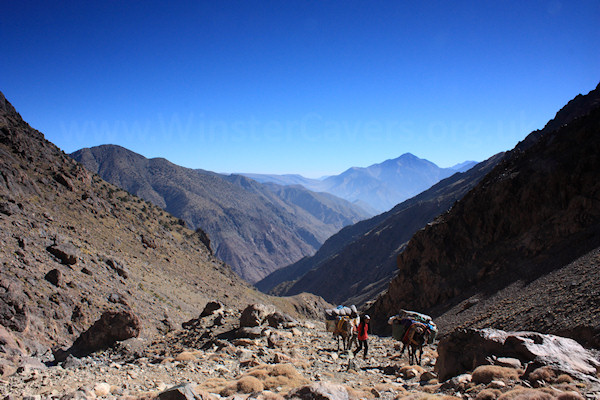
We lunched in the valley below the village of Tacheddirt, before continuing along the valley through the villages of Bonaska, Tamguist and Ouanaskra. After 18km of walking, 930m of ascent and 1200m of descent we have pitched tents at Tinerhourhine, just a km or so short of Ikkiss. An excellent day's walking.
Tuesday 10th September - Tinghourine to Tizi Oussem
|
Our campsite proved to be perfectly comfortable, and after a good night's sleep we were on our way by 8:30am. We were soon past Ikkiss, across the river and on our way up to the col at Tizi n' Aguersioual (2040m) where, surprise surprise, the views were excellent once again.
We descended all the way down to the "main" Imlil road at a slighty depressing 1550m, before embarking on a long, hot climb past Matate and up the col at Tizi n' Oudite (2220m). Here we dined like lords (again!) and rested, before the relatively (and these things are relative) short walk down the South West side of the col, past the village of Ait Aissa, to our gite for the night at Tizi Oussem (1950m). Today's total was a whopping 19km of walking and ~1000m of ascent. From here we expect two short, sharp days climbing to the Toubkal refuge, before we make an attempt at the summit.
We are again in the company of a couple of other travellers, so another evening of exchanging stories is hopefully in order. And going by the fine smells coming from the kitchen, the diet is out the window too.
|
|
Wednesday 11th September - Upwards from Tizi Oussem
The leisurely 9:00am breakfast did precious little to alleviate the shock to the already fatigued system that was the start of today's hike. From the gite, the path rose sharply through the small village of Tizi Oussem, zig-zagging up, and up, and up. And as we left the village, the path continued to rise steeply, far into the distance.
With the cumulative efforts of the previous few days really starting to take their toll, the task of carrying a bit more of our equipment was delegated to our faithful mules - it's astonishing how much difference carrying heavy rucksacks makes. With a slightly rejuvenated spring in our step, we continued up the valley, to the beautiful cascades d'Irhculidine.
We paused at the waterfalls for the obligatory photographs, and pondered the relative merits of stopping for a spot of lunch, or pushing on to camp. Perhaps erroneously, we opted for the latter. The path continued, unrelentlessly upwards. And as we climbed, clouds swept in and out of the valley, the views down to the arid plains far below being obscured and revealed as they did so.
The final push to camp was tough - perhaps a lunch/refuelling stop would have been a better option - but by about 2:00pm we'd made it to a gulley (Assif n'Timellite) with a small waterfall, and a level area just big enough to pitch our tents. We dined at last, and as we did so the clouds continued to lap across the valley sides - with waves of warm sunshine jostling for position with the cool damp mist. As one Winster Caver writes today's blog whilst the rest of our group mostly sleeps, they ponder what to do with the rest of the afternoon. Could go for a walk? Hmmm, maybe not!
Today's total is ~1100m of ascent over 12km - tomorrow is destined to be another short sharp day. Here's hoping that we have sufficient rest time this afternoon/evening to complete the next three days.
Thursday 12th September - onwards to the Toubkal refuge.
Late last night, the clouds cleared away, revealing a perfect starry sky. Far, far in the distance, lights from distant villages could be seen. A cold wind blew, but this was undoutedly a great place to camp. We slept well.
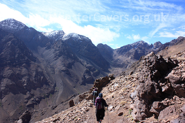
From our camp, our path continued in a rather predictable upwards manner. As seems to be the score for hiking in the High Atlas, we zigged and we zagged, ever upwards, until we reached the col at Aguelzim (3650m). Breaking out at the col, the mighty Toubkal came into view, capped in a light covering of snow. Time to reach for the non-existent wide angle lens once more.
We descended into the valley below Toubkal, skirting along the valley side and arriving, after another 10km walking and 600m of ascent, at the well-placed and rather popular Toubkal refuge (3200m). Having seen so few fellow travellers for the past few days, it's slightly bizarre to be suddenly amongst so many fellow trekkers again. Here we rest for the afternoon and recharge, ready for the ascent of Toubkal itself tomorrow. As we relaxed over lunch, we were pleasantly surprised to meet the travellers we'd encountered at Iabassene, who had just successfully completed their ascent of Toubkal - there were tired, smiley faces all round.
Now - rumour has it that the refuge has some warm showers we can use - time to investigate...
Friday 13th September - Toubkal (4167m)
Rumours - Hmmm.
As the wind whipped up, and the rain started, we made for our woefully inadequate (and somewhat wounded) tent at about 9:00pm last night - the plan was to get started by 5:30am with a view to topping out on Toubkal, and getting down, before the threatened weather came in.
Throughout the night, sharp gusts of wind rattled the tent, the flysheet flapping like a flag. It could have been that it was only the weight of two Winster Cavers that was preventing our nylon abode from becoming airborne!
Tired beyond belief after another night of zero sleep, we crawled out of our sleeping bags at 4:30am, made a half-hearted attempt to eat some breakfast, and at 5:35am we set off.
All things considered, we made pretty good progress. 1000m of pure, uninterrupted ascent. At first, a long rocky gully. A little ant-trail of lights both ahead of us, and behind, as other groups attempted the ascent. Then a few wisps of snow. Then the col, and the short-but-excellent Toubkal ridge. As we approached the ridge, the weather kept its promise, and the snow and the hail started in earnest - short flurries of unwanted freshness. We pushed on, the summit in sight, a break in the clouds, more snow. And after 3 1/2 hours relentless climbing, we made it.
We paused very briefly for the summit photos, before heading back down. Today was not a day for picnics on the hilltops.
As we descended, the foul weather became more and more persistent - the snow at the top turning to rain as we got closer to the refuge, and one Winster Caver becoming desperately tired and full of headache. Fatigue from the lack of sleep and 9 days of strenuous hiking? Or a touch of altitude sickness? Who knows.
Another tough ascent, but worth every moment. Magnifique!
Saturday 14th September - back to Imlil
Dear party of Dutch walkers,
If you're planning on getting up at 5:00am so that you can make an early start up the mountain, please can you have the decency to prepare your rucksacks and other equipment THE NIGHT BEFORE your ascent, instead of spending untold hours rustling, shuffling, turning lights on, off, on, off, rustle, whisper, shout, shuffle, etc. etc. at said 5:00am when the other people in the dormitory are trying to get some very-much-needed sleep.
Thank you,
The Winster Cavers
Despite our early awakening which, in fairness, we were sort-of expecting, we rested well last night. The weather had turned pretty nasty last night. Thankfully, we'd decamped and moved inside the Toubkal refuge for the night - a pleasant enough place, but very busy.
The long walk out from the Toubkal refuge to Imlil was in itself a great walk - the deep valley becoming ever wider and greener, and culminating in a broad river bed by the small village of Armed. Feeling remarkably fresh, we hiked out along the narrow track - a steady stream of hikers, guides, mules and muleteers passing in both directions. The route to/from the Toubkal refuge was justly popular, and of course, it was a Saturday morning, so many were making the mighty Toubkal their destination for the weekend.
As we walked, and walked, the now snow covered peaks became ever more distant. The end of our trek became ever closer. All-in-all, a truly great experience - highly recommended.
Total distance walked: 142km
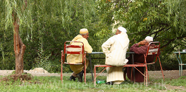
A BIG thank you to our guides - the two Ibrahims (centre & right) and Hassan (left), and our mules Jaqueline and Bia.
The trip was organised with Mohamed at
http://www.trekkinginmorocco.com The service we received was excellent.